Synoptic Analysis
24.7.16
1. Surface Weather Chart Analysis


-
A quasi-stationary Baiu/Meiyu front extended from the Yangtze River basin, across the East China Sea, to south-central Japan.
-
A 990 hPa low-pressure system over Shandong and a ~1010 hPa anticyclone over Manchuria formed a strong meridional pressure gradient, which intensified a 30 kt south-westerly low-level jet (LLJ) over the Yellow Sea.
-
This LLJ transported warm, moist air (dew points of 25–27 °C) toward the frontal zone south of the Korean Peninsula.
-
However, weak local surface convergence limited deep convection to areas south of the peninsula.
2. Upper-Air Weather Chart Analysis

850hPa upper level chart
-
A strong meridional θ-e gradient (≈ 10–12 K) extends from the Yangtze basin to the southern Yellow Sea, outlining the baroclinic zone south of Korea.
-
A warm-tongue (θ-e ≥ 340 K) intrudes toward Jeju and the South Sea, with deeply moist air (dew-point depression < 3 °C).
-
A geopotential low (~1509 gpm near 34°N, 109°E) and a secondary low over Shandong drive a 25–30 kt SSW low-level jet (LLJ).
-
This LLJ enhances moisture transport and frontogenesis, though low-level convergence remains offset from the Seoul–Incheon corridor.

500hPa upper level chart
-
A modest short-wave trough, oriented along 110°E, deepens southeastward over the Yellow Sea, with a closed low centered near 34°N, 119°E (~5702 gpm).
-
Weak meridional height gradients over Korea (∂z/∂y ≈ 1 gpm/100 km) suggest sluggish mid-tropospheric flow, contributing to the stagnation of the frontal boundary at low levels.
-
A subtropical ridge extends northeastward over Kyushu, forming a mid-level confluent col above central Korea.
-
Early westerly blocking and the emergence of a shallow cut-off low initiate a deformation field that will later entrap successive wave disturbances.

300hPa upper level chart
-
A 50–55 kt polar-front jet (PFJ) arcs from the Bohai Gulf across the central Yellow Sea, placing its left-exit region over the Korean Peninsula.
-
A weaker subtropical jet (~30 kt) remains confined south of 25°N; no superposed jet structure is evident yet.
-
Anticyclonic curvature around an upper-level low over Mongolia (~929 gpm) results in modest upper-level diffluence.
-
The entrance of the PFJ’s exit region over Korea initiates weak upper divergence, preconditioning the lower troposphere for ascent, but not yet sufficient for widespread deep convection.
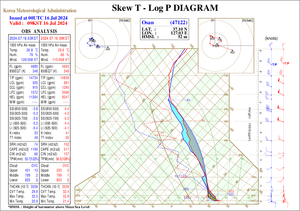
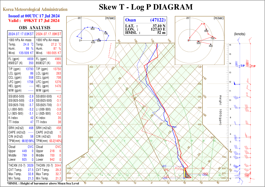
3. Skew-T Log-P Diagram Analysis
-
TPW: ≈54 mm (≈ 222% of July climatology)
-
CAPE: ≈1 190 J kg⁻¹
-
CIN: ≈66 J kg⁻¹
-
LCL: 505 m
-
LFC: 1 572 m
-
0–3 km shear: ~15 m s⁻¹, with veering SSW wind profile
-
A deeply moist, weakly inhibited tropical boundary layer underlies modest mid-level lapse rates (LI₍000–500₎ ≈ –5 K).
-
The environment supports buoyant, pulse-type convection when mesoscale ascent (e.g., frontal lifting or LLJ) sufficiently erodes the shallow CIN lid.
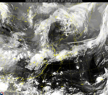
4. Satellite Analysis
-
A broad Baiu–Meiyu cloud band stretches zonally from the East China Sea across southern Korea to Honshu.
-
Cold cloud tops (T ≤ –70 °C) are concentrated within a mesoscale convective complex (MCC) over the central East China Sea and isolated convective bursts along the Yellow Sea warm conveyor.
-
These features indicate early-stage frontal ascent rather than a mature MCS over the Korean Peninsula.

-
A pronounced dry intrusion arcs southeastward from Manchuria to the Yellow Sea, delineating the left-exit region of the polar-front jet.
-
Upper-level divergence is visualised by fanning high-level moisture over the southern Yellow Sea and southern Korea, supporting the developing jet-exit dynamics seen at 300 hPa.

-
A vivid red, comma-shaped dry slot curls over Liaoning and the northern Yellow Sea, highlighting the PV-rich upper-level low from 500 hPa analysis.
-
Cyan–white convective turrets erupt along the Baiu/Meiyu baroclinic zone (East China Sea to Kyushu), while thinner pink–white cloud cover over southern Korea signifies ongoing convective development.
-
The subtropical ridge over the western Pacific appears as a broad, dark-green area, contrasting with the red jet-core signature east of Japan.
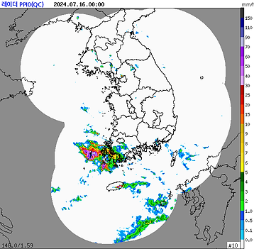
5. Radar Analysis
-
A compact, deep convective system (Zₘₐₓ ≥ 55 dBZ; > 70 mm h⁻¹) is anchored near the Jeollanam-do–South Yellow Sea coastal zone.
-
A distinct V-shaped downshear anvil and sharp reflectivity gradient to the west indicate an organized MCS supported by strong low-level inflow from the East China Sea.
-
Scattered, weak echoes over Gyeongsang and discrete pre-frontal cells south of Jeju reflect moist ascent ahead of the Mei-yu/Baiu front.
-
Minimal returns north of ~36.5°N confirm the baroclinic zone is still displaced south of the Seoul–Incheon corridor.
24.7.17
1. Surface Weather Chart Analysis

-
The Shandong low deepens to 995 hPa and tracks toward the Bohai Gulf, as the baroclinic zone lifts northward, now bisecting central Korea and labeled STNR.
-
Sustained low-level jet (LLJ) forcing drives frontal progression (~29 km h⁻¹), raising surface dew points across the western peninsula to >26 °C.
-
A secondary meso-α-scale low develops near the South Sea, indicating embedded wave activity primed to support diurnal convective bursts.
2. Upper-Air Weather Chart Analysis

850hPa upper level chart
-
The Shandong low intensifies (L ≈ 1433 gpm) and migrates to 37°N; a θ-e ridge (>345 K) intrudes into central Korea.
-
Compressed height gradients across the Yellow Sea enhance thermal wind, veering the LLJ to southerly just offshore.
-
Wet-bulb potential temperatures >22 °C yield θ-e deficits <2 K, eroding convective inhibition above 925 hPa.
-
Warm advection and wave-induced ascent trigger surface pressure falls and initiate the first stratiform-to-convective rainband over Gyeonggi–Chungcheong around 09 KST.

500hPa upper level chart
-
The mid-level trough amplifies and closes at ~5600 gpm over Liaodong; downstream, a barotropic ridge (5888 gpm) strengthens over southwest Japan.
-
A negative-tilt wave develops along 125–135°E, enhancing upper-level divergence over the Yellow Sea.
-
Steering flow over Korea weakens (<10 m s⁻¹), as an Arctic cut-off low stalls over Hokkaido.
-
This trough–ridge juxtaposition effectively anchors the jet-exit region aloft, focusing ascent over the stationary front.

300hPa upper level chart
-
The polar-front jet (PFJ) intensifies to ≥60 kt and adopts a SW–NE tilt across 33–38°N.
-
A jet-streak couplet emerges: PFJ left-exit resides over the Yellow Sea, while a right-entrance streak amplifies over southern Japan.
-
Isotach packing (≥40 kt) aligns with the surface front.
-
Ageostrophic circulations induce strong upper-level divergence (>4×10⁻⁵ s⁻¹) over central Korea—coinciding with LLJ intensification and the onset of convective transition.
3. Skew-T Log-P Diagram Analysis
-
TPW: ≈69 mm (≈ 156% of July climatology)
-
CAPE: ≈0 J kg⁻¹
-
CIN: ≈58 J kg⁻¹
-
SRH: Storm-relative helicity ≳ 460 m² s⁻²
-
A saturated column extends from the surface to ~600 hPa, eliminating buoyant energy while preserving deep moisture.
-
Persistent frontal lifting and an isothermal moist profile support forced ascent, organizing into dynamically driven stratiform–convective rainbands.
-
Large low-level helicity is linked to the accelerating SSW low-level jet diagnosed at the surface.
4. Satellite Analysis

-
Deep convection (T₍B₎ ≤ −70 °C) aligns into a narrow axis of embedded cumulonimbus towers just south of Korea’s west coast—marking the northward extension of the θ-e ridge.
-
A persistent comma-cloud over Liaodong signals the stationary mid-tropospheric cut-off low, while a dry slot curls northward over the Bohai Gulf—hallmarks of cyclone maturity.

-
A classic S-shaped dry intrusion spirals into Liaodong, marking the mature cut-off low.
-
Moisture-laden upper-level outflow fans poleward over central Korea beneath the left-exit region of a 60 kt jet streak.
-
Simultaneous drying over Kyushu reflects subsidence in the right-entrance circulation.
-
Moisture continues streaming northeastward along the stationary front, confirming persistent upper divergence.

-
A tightly coiled red-orange dry-slot encircles the Liaodong cut-off cyclone; a second red-orange band flags the entrance region of the PFJ sweeping across the East Sea.
-
Bright cyan convective cores erupt south of Korea’s west coast, indicating upshear MCS development under the 300 hPa left-exit jet.
-
A discontinuous aquamarine plume from Kyushu to the South China Sea highlights deep low-level moisture feeding the frontal wave.
5. Radar Analysis

-
A quasi-stationary SW–NE-oriented rainband stretches from Jeollabuk-do through Chungcheong into Gangwon interior, with embedded reflectivity peaks of 40–55 dBZ (~20–45 mm h⁻¹).
-
Echo morphology and vertical extent indicate a mature MCS undergoing stratiform-to-convective transition.
-
Persistent training along a ~100 km corridor suggests flash flood risk in the Geum and Han River basins.
-
Regenerating convection over the Yellow Sea (with only weak cold-pool signal) implies a front-parallel feeder pattern sustained by WSW synoptic steering, as supported by the 850 hPa θ-e gradient.
24.7.18
1. Surface Weather Chart Analysis

-
The Liaodong cyclone deepens to 990 hPa as the parent trough acquires a negative tilt, bowing the surface front northeastward into the mid-latitude westerlies.
-
Multiple warm-sector intrusions develop across the peninsula, forming a wavy frontal structure with enhanced baroclinicity.
-
South-westerly low-level jets (≥ 35 kt) intersect the frontal kink south-west of Korea, generating strong frontal upglide and initiating ≥ 80 mm h⁻¹ rainfall maxima over Chungcheong–Jeolla.
-
Upper-level divergence east of Japan, aided by a strengthening coastal low and frontal zone, further anchors the frontal rainbands over Korea.
2. Upper-Air Weather Chart Analysis

850hPa upper level chart
-
A deepening Liaodong low (L ≈ 1396 gpm) bows the baroclinic zone northward, creating sharp θ-e gradients (≥ 15 K across < 300 km) and strong warm advection over Seoul (+4 K day⁻¹).
-
Dew-point depressions < 1 °C up to 700 hPa and 30 kt LLJ support a saturated, unstable column favorable for moist symmetric instability.
-
Tight θ-e packing and curvature vorticity focus slantwise ascent, producing >80 mm h⁻¹ convective bursts over central Korea.

500hPa upper level chart
-
Height falls deepen the Liaodong cut-off low to 5590 gpm, while a secondary shortwave rotates around its southern flank, focusing potential vorticity (PV) advection into Korea.
-
The Kyushu ridge slightly retrogresses, locking the trough axis near 125 °E and maintaining quasi-stationarity over the peninsula.
-
Steering flow remains weak (< 8 m s⁻¹), allowing persistent ascent to support back-building convection and a surface cyclone train across central Korea.

300hPa upper level chart
-
A curved 35–45 kt jet wraps around the Liaodong cut-off, placing Korea beneath persistent left-exit/curvature divergence.
-
Tropopause folding (−36 °C isotherm ~31,000 ft) signals enhanced upper-level PV, promoting conditional symmetric instability.
-
A 40 kt subtropical jet strengthens over the East China Sea, sustaining upper divergence and supporting anchored convective bursts.
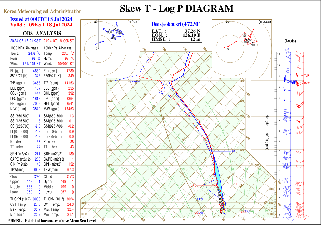
3. Skew-T Log-P Diagram Analysis
-
TPW: ≈67 mm
-
CAPE: ≈230 J kg⁻¹
-
CIN: ≈46 J kg⁻¹
-
LCL: 187 m
-
LFC: 1,818 m
-
Mid-level warm nose (700 hPa): absent
-
Partial destabilization follows wave cyclone passage, with shallow-rooted buoyancy (CAPE < 300 J kg⁻¹) sufficient to sustain back-building convective elements within the rainband.
-
A moist atmospheric column supports high rainfall efficiency despite limited buoyant energy.
4. Satellite Analysis

-
A widespread cold anvil shield with cloud-top temperatures below −70 °C blankets the central Korean Peninsula, marking a mature Mesoscale Convective System (MCS) anchored along the stationary front.
-
The continuous cold-top arc extending from Jeollabuk-do to the East Sea signifies training convection.
-
A newly formed convective burst south of Kyushu reveals the arrival of the next baroclinic wave.

-
A deep, comma-shaped dry intrusion penetrates the peninsula core, associated with strong upper-level divergence and curvature effects.
-
Enhanced upper-level outflow extends from the Yellow Sea to the East Sea, evidencing coupled jet divergence.
-
The dry slot corresponds with potential vorticity (PV) intrusions at 300 hPa, enhancing slantwise instability and supporting extreme convective activity.

-
A continuous bright cyan plume over central Korea denotes a mature convective shield, sharply back-edged by a red dry-slot intrusion, typical of conveyor-belt cyclogenesis.
-
A subsident green-tinted zone over the Sea of Japan reflects the jet-exit downward branch, while the mixed pink–teal frontal band over SE China suggests embedded but still developing convection.
5. Radar Analysis

-
Overnight cold-pool outflow reorients the main convective line into a classic SW–NE squall structure from the Yellow Sea coast through central Gyeonggi to the DMZ.
-
Reflectivity core ≥ 60 dBZ at the southwestern tip indicates renewed surface-based convection.
-
Bowing segment near 36°N, 126.5°E reveals mesoscale rear-inflow jet penetration, suggesting potential for damaging straight-line winds locally.
-
Transition to widespread stratiform rain (>10 mm h⁻¹) over northern Gyeonggi and Hwanghae marks the cool-sector stratiform shield poleward of the front.
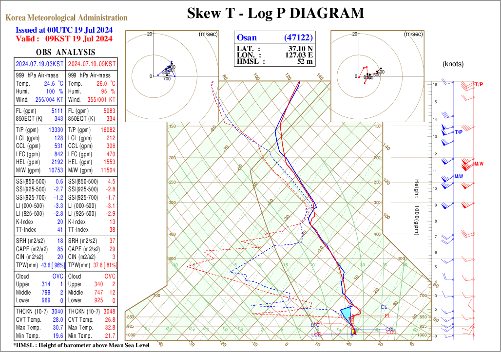
24.7.19
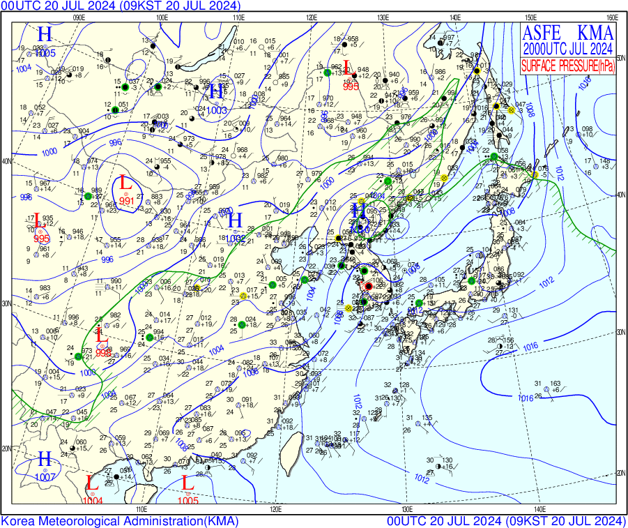
1. Surface Weather Chart Analysis

-
As the Liaodong system occludes and moves into the Sea of Japan, a 986 hPa Yellow Sea wave cyclone advances poleward along the frontal zone.
-
Its warm conveyor belt intensifies a moist south-westerly jet (>25 kt) parallel to the peninsula’s terrain, causing frontal–orographic locking.
-
Sea-level pressure falls of 2–3 hPa per 3 hours and sustained surface convergence occur along the west coast.
-
Extreme hourly rainfall totals (>90 mm) are recorded from Daejeon to Suwon.
2. Upper-Air Weather Chart Analysis

850hPa upper level chart
-
A secondary Yellow Sea wave (L ≈ 1391 gpm) shifts poleward, aligning the front zonally near 36°N.
-
A θ-e ridge (>350 K) coincides with maximum height falls west of Daejeon; warm advection weakens north of 37°N, sharpening frontogenesis near Suwon.
-
Veering winds (180° at 30 kt → 240° at 15 kt) generate shear convergence along the west coast.
-
Moisture convergence and isentropic ascent lock the stationary front over the Seoul–Suwon corridor, driving a second rainfall peak (>90 mm/hr).

500hPa upper level chart
-
The primary cut-off low begins filling (5585 gpm) but remains quasi-stationary; a new impulse produces a short-wave trough over the Yellow Sea.
-
A downstream ridge strengthens over the NW Pacific (5951 gpm), blocking eastward movement.
-
Diffluent flow and vorticity regeneration sustain synoptic-scale ascent, supporting the second rainfall maximum.

300hPa upper level chart
-
Jet axis remains quasi-stationary; a new cyclonic jet streak (35–40 kt) forms over the Yellow Sea, maintaining left-exit region divergence over Gyeonggi–Chungcheong.
-
The PFJ ridge over Japan retracts, tightening the jet waveguide.
-
Vertical shear peaks above 35 m s⁻¹ (300–850 hPa).
-
Enhanced upper-level divergence overlays the secondary surface cyclone, prolonging extreme rainfall despite mid-level warming.
3. Skew-T Log-P Diagram Analysis
-
TPW: ≈44 mm (>90% of normal)
-
CAPE: ≈85 J kg⁻¹
-
CIN: ≈20 J kg⁻¹
-
Mid-level lapse rates: weak (SSI₍₈₅₀–₅₀₀₎ ≈ +0.6 K)
-
Aloft dry-slotting associated with the Yellow Sea wave cyclone stabilizes the atmospheric column.
-
Convection transitions to predominantly warm-rain and slantwise modes, reducing deep convective activity.
-
Despite stabilization, high cloud-bearing moisture combined with strong isentropic ascent sustains extreme hourly rainfall totals through efficient microphysical processes.
4. Satellite Analysis

-
Meridionally elongated cloud shield with embedded −70 °C cores follows the rejuvenated frontal wave.
-
Intense cloud tops extend from Daejeon to the southeast coast, indicating vigorous convection.
-
Dry intrusion between Liaodong and Hokkaido reflects upper-level jet entrance dynamics sustaining large-scale ascent over Korea.

-
Dual spiral dry vortices form over Liaodong and the western Pacific, creating a diffluent jet waveguide.
-
A moist plume stretches meridionally across Korea, supporting rapid moisture transport and cloud-top fanning linked to jet-streak divergence.
-
This mechanism triggers the second intense rainfall peak.

-
Bright cyan plume aligns with the revived stationary front over central Korea, signaling deep moist convection.
-
Red–orange shading to the west marks stratospheric dry-air intrusion, reinforcing frontogenesis and stabilizing the dry slot.
-
Cyclonic red-cyan swirl near 35°N, 150°E corresponds to the baroclinic wave at 500 hPa, highlighting upper-level vorticity maxima.
-
Night-time IR enhances day–night continuity of the jet-core.
5. Radar Analysis

-
Frontal zone shifted south overnight; new convection focuses over Jeonnam–Gyeongnam coast and Jeju Strait.
-
Embedded supercells (>65 dBZ) indicate conditional symmetric instability and enhanced low-level shear downwind of the Tsushima Warm Current.
-
Echo absence over central peninsula confirms transient post-frontal dry slot, easing flooding in Chungcheong provinces.
-
Southward-moving MCS over East China Sea reflects secondary jet-induced ascent behind subtropical ridge, sustaining rainfall potential.
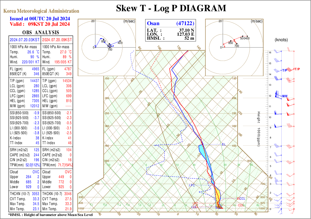
24.7.20
1. Surface Weather Chart Analysis

-
The wave weakens to ~994 hPa over northeast China, while its trailing trough curves cyclonically, deforming the front into an S-shape across Korea.
-
Baroclinic zone stalls beneath weak 500 hPa height tendencies (~14 km h⁻¹), allowing deep moisture pooling over the central peninsula.
-
Convective training develops along the stationary segment; mesoscale pressure perturbations (~3–4 hPa) are evident via the 1004 hPa isobar indentation southwest of Seoul.
2. Upper-Air Weather Chart Analysis

850hPa upper level chart
-
The wave occludes; θ-e gradients weaken (~6 K), but a residual warm pool (~348 K) lingers over the western coastal plain.
-
A mesoscale trough behind the occlusion maintains localized confluence along 127–128 °E, even with fading synoptic-scale lift.
-
CIN re-emerges (>75 J kg⁻¹) south of 34°N, but remains weak north of 36°N.
-
S-shaped frontal deformation and mesoscale confluence sustain echo training in a marginally stabilised environment, consistent with flash-flooding near the Han River tributaries.

500hPa upper level chart
-
The trough elongates SW–NE, while relaxed geopotential gradients over Korea (∂z/∂x ↓) reflect weakening dynamic forcing.
-
The westerly jet core retracts toward 40°N, 145°E; steering flow over Korea turns westerly at ~12 m s⁻¹.
-
A warm-advection ridge (~5876 gpm) over southern China expands northeastward, compressing the decaying trough.
-
These conditions favour slow southward frontal progression, but persistent deformation maintains mesoscale ascent.

300hPa upper level chart
-
PFJ weakens to 30–35 kt and shifts poleward; isotachs reveal a split-jet structure, with a weaker southern branch (~25 kt) over the East China Sea.
-
Divergence maximum shifts east of 130°E, placing Korea beneath the right-entrance (subsident) region of the decaying streak.
-
300 hPa heights rise by 20–30 gpm over Korea.
-
Upper-level subsidence stabilises the column; however, residual low-level convergence and shallow instability maintain localized echo training.
3. Skew-T Log-P Diagram Analysis
-
TPW: ≈52 mm
-
CAPE: ≈240 J kg⁻¹
-
CIN: ≈200 J kg⁻¹
-
A capped, conditionally unstable profile emerges as a pronounced 850 hPa warm layer (+2 K above the moist adiabat) suppresses deep convection despite modest buoyancy.
-
Frontal sagging beneath mid-tropospheric subsidence maintains inhibition; however, mesoscale pressure troughs locally breach the cap, producing narrow echo-training corridors and yielding the observed S-shaped convective structure.
4. Satellite Analysis

-
Cold-top coverage retreats significantly.
-
Isolated –70 °C cells persist along the West-Coast sea-breeze convergence (34–35 °N), while the main frontal shield exits east of Honshu.
-
This marks a substantial reduction in widespread deep convection, consistent with weakening upper-level divergence at 300 hPa.

-
Dry intrusion begins to erode and retreat northeastward.
-
Fragmented moist plumes reflect a decoupled jet structure, with the PFJ over Honshu and a weaker STJ branch over the East China Sea.
-
Korea lies beneath drier, subsident air—matching reduced mid–upper tropospheric ascent.

-
Polar jet shifts poleward (≥42 °N); red shades recede, and Korea enters a duller green–brown regime—visually confirming reduced upper-level forcing and weaker cloud-top cooling.
-
Discrete cyan cells appear over the Yellow Sea, aligned with residual sea-breeze convergence.
-
South of 20 °N, a warm-core cyclone emerges in the western Pacific, highlighted by tightly coiled cyan spirals.
5. Radar Analysis

-
Composite reflectivity shows a narrow, shallow convective band (~33°N, 30–45 dBZ) along the stalled front near Kyushu–East China Sea.
-
Echo tops are low, limited by mid-level warming and dry air.
-
Rainfall rates remain below 10 mm h⁻¹, with weak convective organization.
-
Over Korea, reflectivity is minimal due to subsidence behind the 500 hPa short-wave trough, marking the lowest radar activity since 16 July and a temporary pause in the rainfall event.
-
Weak convergence near the Yellow Sea coast causes occasional low-topped showers without significant accumulation.
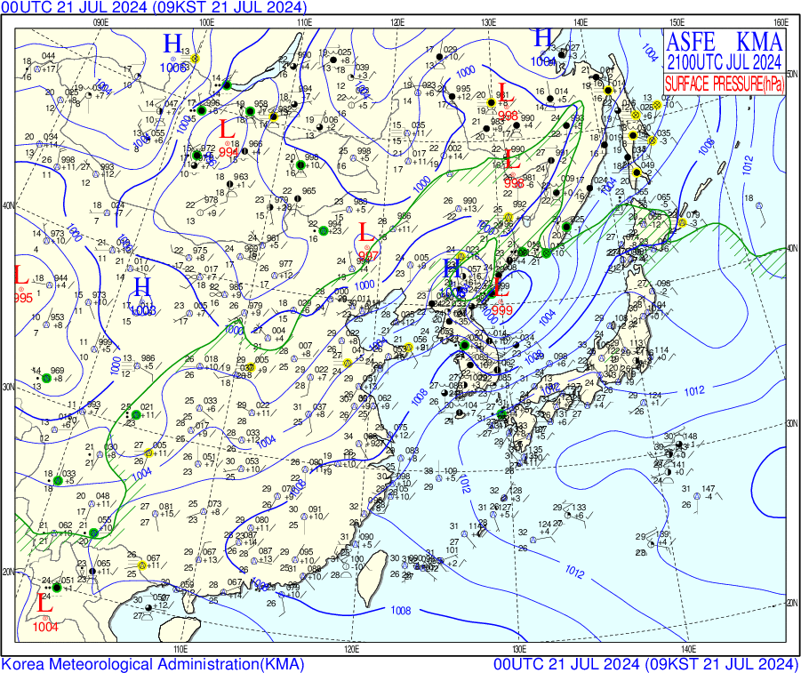
24.7.21
1. Surface Weather Chart Analysis

-
A new meso-α low (~999 hPa) forms east of Mokpo, steering the front sharply northeastward before ascending into the East Sea.
-
Surface winds veer to south-easterly along the southern coast, briefly enhancing marine moisture inflow.
-
The frontal rainband narrows but intensifies over southeast Gyeonggi where topography intersects the 14 km h⁻¹ translation vector, producing the event’s final day of >100 mm rainfall.
-
Down-valley katabatic drainage behind the low begins to reduce precipitable water across central Korea.
2. Upper-Air Weather Chart Analysis

850hPa upper level chart
-
Height rises (~1448 gpm) spread southeastward as the baroclinic zone retreats; elevated θ-e (>345 K) lingers east of Mokpo.
-
Weak cold advection (−2 K/12 h) erodes the central ridge. South-easterly winds along the southern coast induce shallow upslope flow into Gyeongnam.
-
Moisture convergence decreases by ~50% from peak intensity.
-
The narrowing rainband shifts ENE with waning strength, reflecting reduced convergence and stabilisation aloft.

500hPa upper level chart
-
A flattened wave train extends from Lake Baikal to Japan, with the Liaodong cut-off lifting toward Primorsky Krai (5674 gpm).
-
Strengthened zonal flow (~20 m s⁻¹ at 37°N) disrupts the prior blocking pattern.
-
Broad subsidence spreads over Korea, indicated by weak positive temperature advection at 500 hPa.
-
Removal of the closed low and restored zonal flow reduce upper-level divergence, initiating decay of persistent rainfall.

300hPa upper level chart
-
The jet stream axis straightens along 38–40°N at ~40 kt, with the jet-exit region shifting offshore over the East Sea.
-
Divergence maxima relocate eastward; upper-level vertical shear over Korea decreases below 25 m s⁻¹.
-
An eastward-propagating warm advection ridge aloft accompanies these changes.
-
With upper-level divergence removed, deep convection rapidly diminishes, transitioning to stratiform and more migratory rainfall patterns.
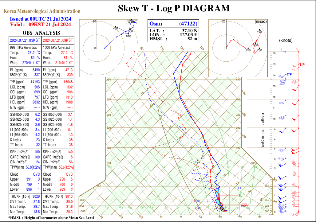
3. Skew-T Log-P Diagram Analysis
-
TPW: ≈57 mm
-
CAPE: ≈110 J kg⁻¹
-
CIN: ≈24 J kg⁻¹
-
SSI₍₈₅₀–₅₀₀₎: +6.0 K
-
Shear (300–850 hPa): Weakening trend
-
Moist-neutral stratification dominates the column
-
Residual moisture remains, but diminished instability and shear
-
Environment unfavourable for organised convection; supports light stratiform rain
4. Satellite Analysis

-
Deep convection retreats offshore into the Sea of Japan; −70 °C tops cluster around the departing wave cyclone.
-
Over land, only patchy stratiform cloud remains, consistent with subsidence beneath the jet right-entrance region.

-
Moisture plume shifts eastward; widespread dry mid-level subsidence dominates the peninsula.
-
Zonal upper-tropospheric flow evident from parallel WV bands along 40 °N, confirming the reestablishment of mid-latitude westerlies.
-
Central Korea exhibits faint transverse features, hinting at shallow residual ascent.

-
Dominant red shading indicates large-scale subsidence over Korea.
-
Disorganised pink cloud debris confirms convective decay.
-
Dual jet streaks (PFJ and STJ) arch zonally into the North Pacific, visualising the fully straightened jet.
-
A compact cyan–white bubble south of 25 °N 120 °E marks a newly developing tropical disturbance.
5. Radar Analysis

-
A renewed convective band (~45–55 dBZ) extends from Jeollanam-do to Gangwon—typical TL/AS morphology.
-
Alignment parallel to low-level flow supports echo training and prolonged rain over the same catchments.
-
Flash-flood risk resurfaces in the Keumho and Nakdong basins.
-
Scattered upstream echoes over the Yellow Sea suggest overnight back-building, in agreement with resumed low-level θₑ advection at 850 hPa.
24.7.22
1. Surface Weather Chart Analysis

-
Synoptic control shifts to a shallow continental ridge (1008–1010 hPa) extending from Manchuria to Korea.
-
The baroclinic zone subsides south of the peninsula and connects to TS Prapiroon (997 hPa) over the northern South China Sea.
-
Weak post-frontal westerlies and decreasing dew-points (<22 °C) mark the end of the multi-day stationary front.
-
Residual stratiform rainfall limited to the retreating frontal tail near Jeju Island.
2. Upper-Air Weather Chart Analysis

850hPa upper level chart
-
A broad high (H ≈ 1432 gpm) dominates Manchuria; θₑ ridge shifts south of 34 °N.
-
Dew-point depressions of 5–7 °C north of 37 °N signal sharp drying.
-
A residual low (L ≈ 1359 gpm) over the East Sea induces offshore flow, removing inland convergence.
-
Prapiroon sustains θₑ > 350 K in the retracted frontal zone south of Jeju.
-
Moisture conveyor shifts south; only light rain persists along the front’s southern fringe.

500hPa upper level chart
-
A short-wave transits Manchuria (5688 gpm), but zonal flow dominates with heights ≥ 5790 gpm south of 35 °N.
-
Steering winds increase (>25 m s⁻¹), evacuating residual moisture plumes eastward.
-
Subtropical ridge consolidates (5935–5940 gpm) over the East China Sea.
-
Loss of forcing and deformation collapses the front into the South-China-Sea monsoon regime.

300hPa upper level chart
-
PFJ weakens to 30 kt north of 40 °N; subtropical-level winds <25 kt over Korea.
-
Broad upper-level convergence sets in as jet streaks align with the ridge axis.
-
A TUTT lingers south of 20 °N but remains disconnected from Korean circulation.
-
Jet-related ascent ceases; convergent upper flow confirms termination of the rainfall event.
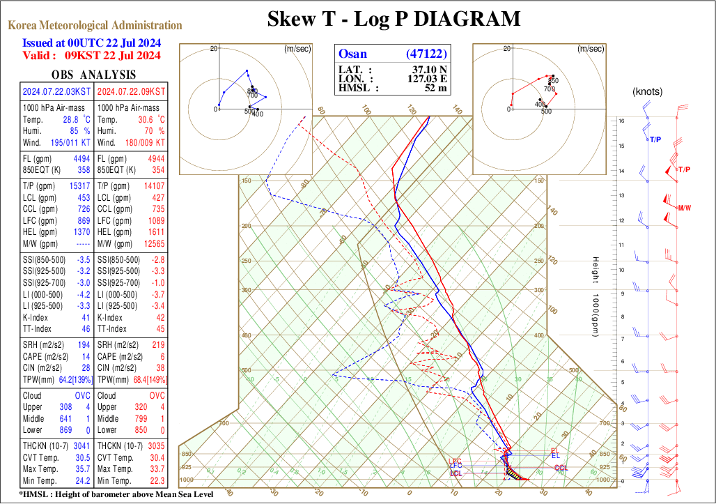
3. Skew-T Log-P Diagram Analysis
-
TPW re-peaks at 64 mm (≈140 %).
-
CAPE ≈ 15 J kg⁻¹
-
CIN ≈ 28 J kg⁻¹
-
LI₍₀₀₀–₅₀₀₎ ≈ –4 K; slight mid-level warming offsets lower-level instability.
-
The retreating front leaves behind a humid but weakly unstable profile over central Korea.
-
In the absence of significant lift or instability, precipitation transitions to light stratiform drizzle, signaling final event dissipation.
4. Satellite Analysis

-
No cold anvils remain over Korea.
-
−70 °C tops confined to TS Prapiroon and a secondary tropical vortex over the South China Sea.
-
Korea lies beneath a dry mid-tropospheric slot, visually confirming the termination of the prolonged rainfall event.

-
A well-defined dry slot spans the peninsula, with strong upper-level anticyclonic outflow over NE Asia.
-
Moist ascent now restricted south of 33 °N, associated with TS Prapiroon.
-
Baroclinic moisture conveyor fully withdrawn → consistent with jet-level convergence in the final 300 hPa analysis.

-
Peninsula under muted greens and browns → minimal high cloud.
-
Bright cyan tropical convection over:
-
(i) TS Prapiroon (Gulf of Tonkin)
-
(ii) Departing wave cyclone over Primorsky Krai
-
Narrow red ribbon (jet axis) retreats north of 45 °N.
-
Distinct separation of tropical convection vs mid-latitude subsidence illustrates final regime decoupling.
5. Radar Analysis

-
Echo-free across most of Korea; only scattered ≤15 dBZ returns NW of Seoul.
-
Frontal surface and moisture plume have lifted into the Sea of Japan.
-
Subsidence beneath a mid-tropospheric ridge suppresses convection.
-
Composite signals transition to post-event recovery; only isolated sea-breeze showers possible later diurnally.